Skip to content Skip to sidebar Skip to footer

Mount Timpanogos Epic Hiking Guide

Mount Timpanogos was the first “serious” Utah mountain I hiked after moving to the state. If it weren’t for the company outing that prompted this adventure, I’m not sure hiking Mount Timpanogos would’ve happened! But I’m so, so glad it did–a strenuous but absolutely gorgeous hike.

Table of Contents

Mt. Timpanogos Hike Overview

Timp is a very popular hike among Utah locals. Located in Salt Lake Valley and tucked in American Fork Canyon, it’s the second-tallest peak in the Wasatch mountain range (Mt. Nebo being the tallest). Timp’s summit sits at 11,752 feet and provides expansive views of Salt Lake Valley and the surrounding wilderness. Wedding photo shoots, sunrise summiting and camping at Emerald Lake are some common activities. 

mt-timpanogos-meadow

I think of this mountain as having “chapters”, each as breathtaking as the next. If you take the Timpooneke route, you’ll start by walking through aspen forest, followed by sprawling green meadows with wildflowers, then up the rocky saddle to the summit. 

mt-timp-grassy-ridge

Two Main Timpanogos Trailheads

There are two ways to reach Timpanogos Summit: the Timpooneke Trail or the Aspen Grove Trail. Both trailheads are in American Fork Canyon and are a 22-minute drive apart from each other. While similar in length, Timpooneke remains more popular for reasons not totally clear. Maybe because it’s a little shorter and has less elevation gain. You have the option of taking one route up and the other route down to maximize epic views, too! 

Timpooneke Trail Quick Facts (More Popular)

  • Trailhead coordinates: 40.43141, -111.63908
  • 15 miles out & back
  • 4,425 ft elevation gain
  • Difficulty: hard, though less steep than Aspen Grove Trail
  • Lots of wildflowers & scenery
  • Must hike an additional 1.8mi RT to visit Emerald Lake
  • Dogs are allowed
  • No campfires allowed
  • $6 canyon entrance fee
Map Of Timpanogos Hike via Timpooneke Trail
timpanogos-hiking-map-picture-timpooneke
Map image via AllTrails

Aspen Grove Trail Quick Facts

  • Trailhead coordinates: 40.40438, -111.60431
  • 15.6 miles out & back
  • 5,383 ft elevation gain
  • Difficulty: hard, with steep sections
  • Lots of waterfalls, including Stewart Falls
  • Passes by Emerald Lake (popular camp spot)
  • Dogs are allowed but must be on leash
  • No campfires allowed
Map Of Timpanogos Hike via Aspen Grove Trail
mt-timpanogos-hiking-map-picture-aspen-grove-trail
Map image via AllTrails

How Long Does It Take to Hike Mt. Timpanogos?

mountain-goat-timpanogos-saddle
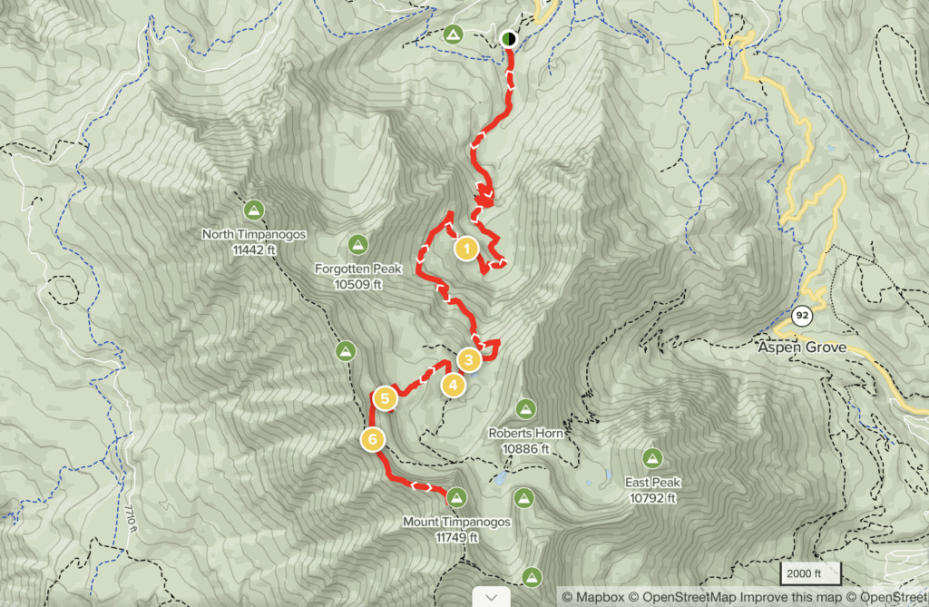
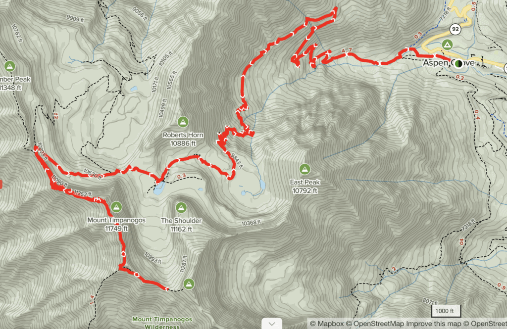
Anywhere from 6-10 hours. My crew took about 8 hours but it all depends on your pace and which route you choose. Aspen Grove Trail will probably take longer because it’s over a half mile longer and you’ll climb 958 ft more in elevation than Timpooneke Trail.

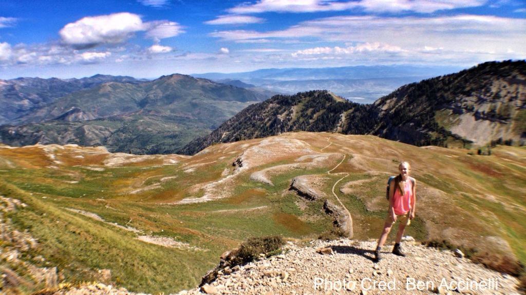
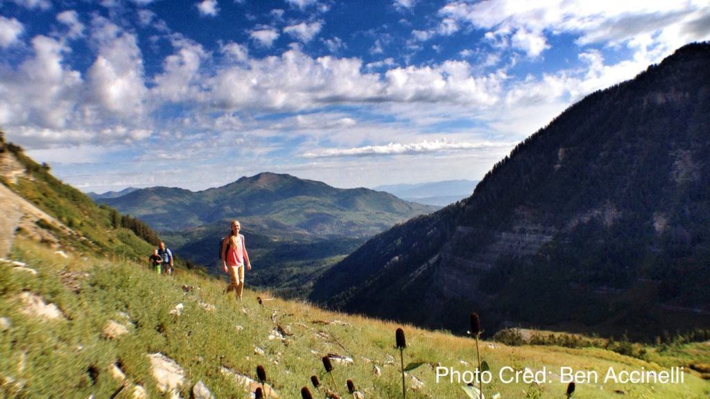
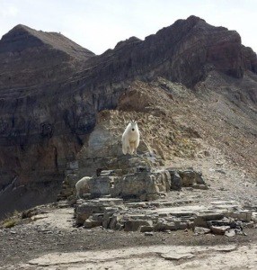
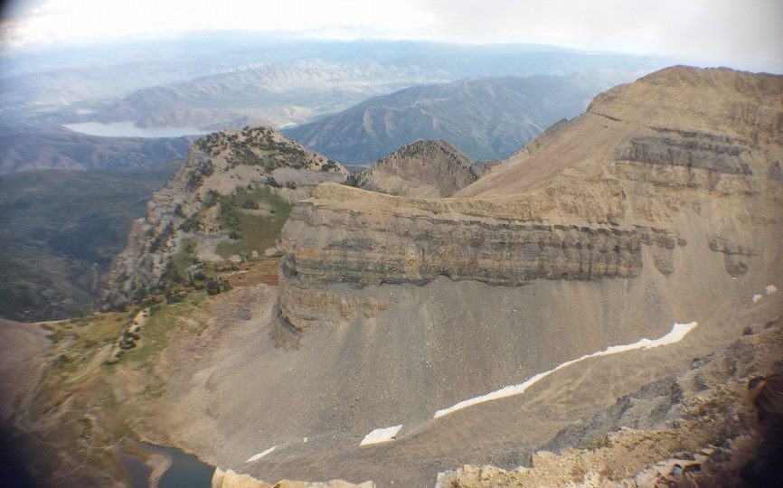
Both trails are stunning in their own ways and provide chances to see wildlife, including mountain goats! My crew took the Timpooneke Trail and started our hike around 7am. We saw lots of mountain goats and even had a slight scare when one of our dogs chased after one! Thankfully, no goat or dog was harmed. I can’t recall exact times but total hiking time was roughly 8-9 hours. 

hilary-timpanogos-summit-background

Reaching Timp Saddle

The Aspen Grove trail and Timpooneke trail converge at what’s known as Timp Saddle (coordinates are 40.3966, -111.655). Timp Saddle is 5.9 miles from Timpooneke Trailhead and 6.1 miles from Aspen Grove Trailhead. It will take about 3-4 hours to reach from either route. The Timp Saddle provides vast views of Salt Lake Valley and a glimpse of the summit. This is where we spotted the most mountain goats.

timpanogos-saddle-salt-lake-valley

From the saddle, you follow a rock ridgeline for about a mile until you reach the summit. You’ll know you’re at the summit when you see a small, old shack. You can go inside the shack, which was used by early surveyors as a triangulation point, according to Utah.com

timp-summit

What’s the Best Time of Year to Hike Mt. Timpanogos?

The recommended timeframe for hiking Timp is between June and October. But if you want to maximize your chances of seeing wildflowers (and not snow), I recommend late June to early August. My crew went in late August and while still beautiful, a lot of the wildflowers had been scorched and browned from the summer’s hot sun. 

Snow can start appearing as early as October–and even without snow, it’s going to be pretty cold at those elevations in October!

timp-summit-wilderness

How to Prep for Hiking Mt. Timpanogos

1. Bring LOTS of Water

timpanogos-rock-ridgeA good rule of thumb is to drink half a liter of water every hour of moderate hiking, in moderate temperatures. This can increase to one liter per hour if you’re exercising harder in hotter temperatures. Hiking Mount Timpanogos can take anywhere from 7-10 hours, so I recommend having about 4-8 liters of water with you. 

You’ll only have access to water for the first two miles on the Timpooneke trail. Although I didn’t have it on this hike, I now use this Gregory 3 liter hydration pack and I like its design and ease of use. There are lots of water spots on Aspen Grove Trail If you have a water filter you plan to use. But I still recommend bringing plenty of your own water because it’s risky to rely on external sources.

2. Bring Sun Protection

Regardless of which route you take, be prepared to spend hours under the sun. Both trails are exposed and only get more exposed as you climb in elevation. Sunscreen, baseball cap, and sunglasses are a must!

3. Pack Protein-Rich Snacks

Beef jerky, trail mix, Clif bars, peanut butter and bananas are staple items for a long hike. Between the sun exposure, the mileage of the hike, and elevation gains, I recommend fueling your body with slow-burning food to maintain energy levels.

4. Dress for Changing Climates

I started this hike in a thin tank top and shorts. By the summit, I was wearing a beanie cap, a windbreaker and long pants. As you climb in elevation, temperatures get cooler.

Especially once you reach Timp Saddle, the wind is constant and impossible to escape. If it’s already chilly out, be prepared to stay warm! The weather can also change on a dime and afternoon thunderstorms are common in the summer.

5. Consider Hiking Poles

It’s worth considering bringing hiking poles. A large portion of this hike involves walking through shoal rock and it takes a toll on knees. I’ve never had serious knee problems and hiked this trail at the age of 22.

But I still resorted to walking backwards for the last half mile just to take pressure off of my knees. They were aching terribly. It was something I’d never experienced before. It’s amazing I didn’t trip over myself in the process, LOL.

*********

Hiking Mount Timpanogos was an epic way to familiarize myself with my new home state! I understand why it’s one of the most popular hikes among Utah locals. If you’re looking for a taste of Utah without the strenuous mileage and elevation, check out my favorite easy hikes in Millcreek Canyon

Save this on Pinterest

timp hiking guide pinterest

Leave a Comment

Get Exclusive Tips & Stories

Sign up below to receive monthly email updates! Whether it's a hilarious short story or a special offer, I'll be including content that isn't on my website.

* indicates required